Our contour and detail surveys are comprehensive, covering all aspects of your property that could impact the design and construction process.
Contour and detail surveys are a vital part of the residential development process in Northern NSW. These surveys provide detailed information about the existing structures, natural features, and ground levels of your property. Whether you're planning a new build, renovation, or landscaping project, contour and detail surveys are essential for ensuring that your designs are both practical and compliant with local regulations.
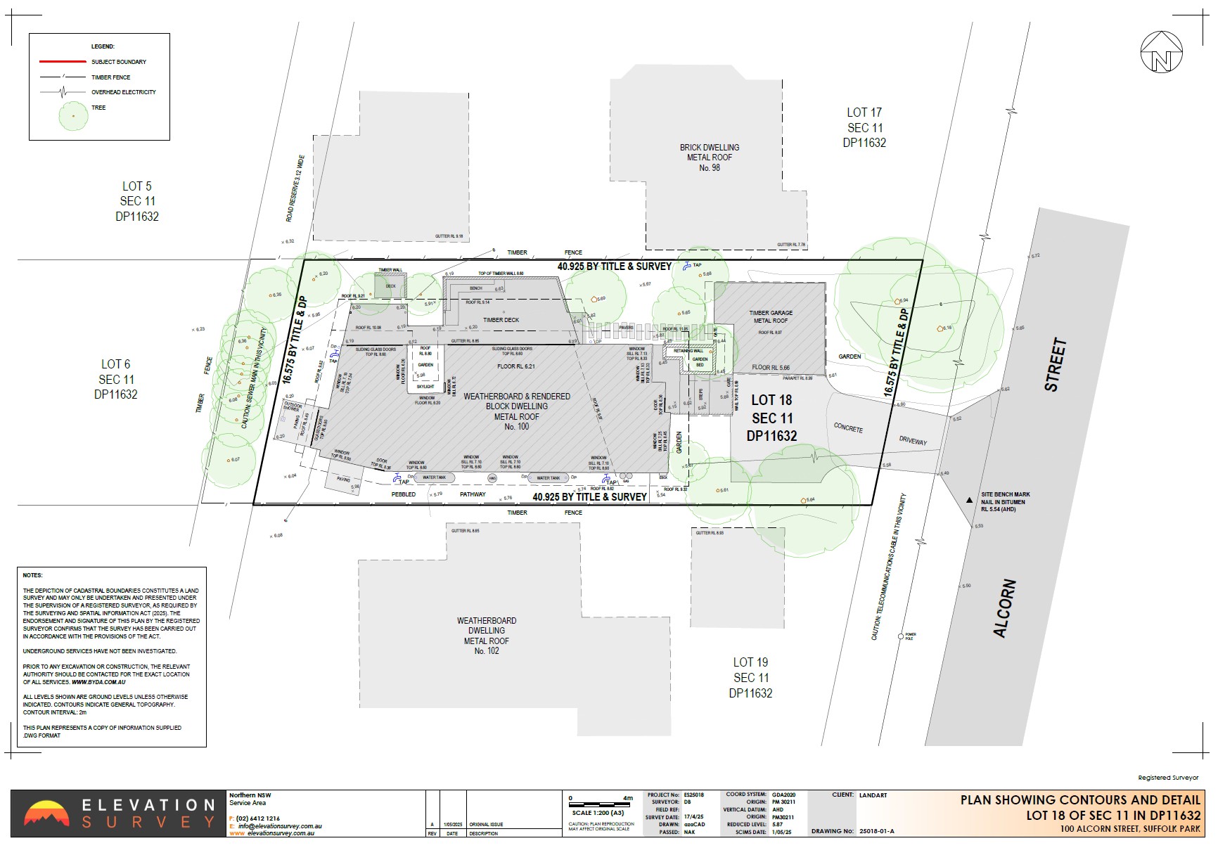
Contour and detail surveys typically includes the following:
Detailed information on the slopes and gradients of the land.
Locations and dimensions of buildings, sheds, garages, and other man-made structures.
Positions of trees, rock outcrops, and watercourses.
The precise location of property boundaries, which can be critical for design and legal purposes.
Information on underground services such as water, gas, and sewer lines.
Relevant details from neighbouring properties, including structures and boundaries that may impact your project.
Contour and detail surveys are carried out to collect comprehensive data about a piece of land, which is then compiled into a contour and detail plan. This plan illustrates both the natural and man-made features present on the site. It can also be referred to as a detail survey, feature and level survey, or contour survey plan; this type of survey is essential for accurately capturing the land's contours, structures, and other significant features.
The resulting contour and detail plan shows the levels of the land, the location of elements like buildings, trees, and fences, as well as any other improvements on the site. It can also include details on underground features and relevant aspects from neighbouring properties, providing a complete picture of the area in question. Local councils might also refer to these surveys as site analysis plans or boundary identification surveys.

A contour and detail survey is required in various stages of property development. It is crucial when designing additions, renovations, or extensions to your home. Architects, builders, and landscapers rely on this survey to understand the unique characteristics of the land, such as slopes, existing structures, and vegetation.
Local councils often require a Contour & Detail Survey as part of the approval process for any construction or significant landscaping work. By obtaining a detailed survey, you ensure that your project meets all necessary guidelines and maximises the potential of your property.

We pride ourselves on delivering high-quality surveying services with professionalism and precision. At Elevation Survey we provide accurate and reliable data, ensuring that your project starts on a solid foundation. Our contour and detail surveys are comprehensive, covering all aspects of your property that could impact the design and construction process. This thorough approach ensures that you have all the information you need to make informed decisions and avoid costly surprises during your project.
At Elevation Survey, we work closely with you, your architect, and your builder to ensure that the survey meets all necessary requirements and provides the information needed for a successful project. We keep you informed throughout the process and are always available to answer any questions or address concerns.
Elevation Survey specialises in offering 3D laser scanning with BIM modelling to your project, we have been trained in latest 3D surveying practices that can significantly benefits your project.
engineers.
We can also integrate As-Built or Existing Conditions Floor Plans with your Contour & Detail Survey to provide a full site analysis. These plans are essential for understanding the current layout of buildings on your property, making them invaluable during the design stage of renovations or refurbishments. By combining these services, we offer a complete picture of your property, helping you make informed decisions.


It's best to obtain a contour and detail survey early in the planning stages of your project. This will ensure that your architect or designer has all the information they need to create a plan that maximises the potential of your land and meets regulatory requirements.
The duration of a contour & detail survey can vary depending on the size and complexity of your property. However, most surveys can be completed within a few days, with the final plans delivered within one to two weeks.
Yes, combining a contour & detail survey with other surveys, such as a cadastral boundary survey or as-built floor plans, can provide a more comprehensive understanding of your property. This can be particularly beneficial for larger or more complex projects.
Ready to move forward with your project? Contact our team today to get a quote fast! Whether you're a homeowner building your dream home, a developer elevating a community, or a government agency, our experienced surveyors are here to assist you with all your surveying needs.
.jpg)

